(Source: Alina et al. 2024).
We are happy to announce our most recent publication from the MIGRAWARE Project.
Abstract:
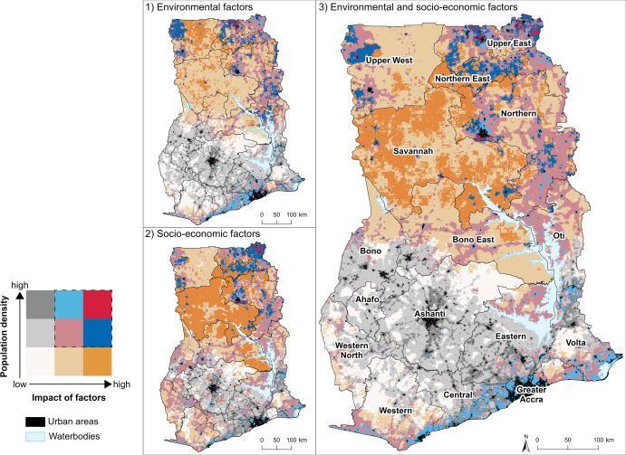
Rural communities in Ghana, dependent on agriculture and lacking resources and infrastructure, are highly vulnerable to climate and environmental change. Internal migration is often considered as a strategy to mitigate local livelihood constraints. Understanding the challenges of rural communities requires knowledge of local conditions. As only few studies have mapped vulnerable areas in the context of migration in Ghana at a spatially explicit and nationwide level, this study provides a geodata-based examination of how rural areas in Ghana are vulnerable to multiple, co-occurring socio-economic and environmental factors influencing migration. A multifactorial and expert-based weighted overlay analysis was applied, integrating diverse data sources including climate, remote sensing, and recent census data from Ghana. Bivariate maps visualize vulnerable areas where a high impact of the factors coincides with a high rural population density. High levels of factor impact are observed in the northern regions and coastal areas of Ghana. Relatively low impact is found in more central parts of the country. The results align with current net migration rates, confirming the applicability of our method for assessing rural internal migration. This method enhances the understanding of migration dynamics in Ghana and emphasizes the role of spatial data in migration studies.
Read Full Article Here.
Lead Author: Alina Schürmann (PhD Candidate on the MIGRAWARE Project)